- التسوق ، اصبح سهلا.
- /
- احصل على التطبيق!
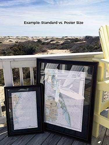
New York Lower Bay (Northern Part) NOAA 12402. This Framed Nautical Map covers the waterways and coast line of the New York Lower Bay (Northern Part). The Framed Nautical Chart is the official NOAA Nautical Chart detailing the beautiful waters of the bay; including Staten Island, Coney Island, Gravesend Bay and Parts of Brooklyn. NOAA Nautical Chart 12402. Standard frame is approx 18" H x 24‚ W. Poster frame is approx 28" H x 36" W. Solid Hardwood Frame, Glass Front, Black Mat, Paper Duster Backing with Wire Hanging, Handmade in USA
 -16%
دريسدن الحديثة تمامًا: البناء السريع والسهل: 13 مشروع لحاف حيوي لجميع مستويات المهارة
SAR 123
-16%
دريسدن الحديثة تمامًا: البناء السريع والسهل: 13 مشروع لحاف حيوي لجميع مستويات المهارة
SAR 123
 ساعة كوارتز تناظرية كلاسيكية للبالغين من ستار وورز ذا ماندالوريان
SAR 100
ساعة كوارتز تناظرية كلاسيكية للبالغين من ستار وورز ذا ماندالوريان
SAR 100
 -42%
رحلة تخييم مع السيد ماجي: (قراءة الكتب بصوت عالٍ، سلسلة كتب للأطفال، كتب للقراء الأوائل) (السيد ماجي، MCGE)
SAR 58
-42%
رحلة تخييم مع السيد ماجي: (قراءة الكتب بصوت عالٍ، سلسلة كتب للأطفال، كتب للقراء الأوائل) (السيد ماجي، MCGE)
SAR 58
 Gzrlyf دفتر ملاحظات مدرب التشجيع - فقط أقوى النساء يصبحن مجلة مدربي التشجيع - هدايا مدرب التشجيع (أقوى النساء)
SAR 83
Gzrlyf دفتر ملاحظات مدرب التشجيع - فقط أقوى النساء يصبحن مجلة مدربي التشجيع - هدايا مدرب التشجيع (أقوى النساء)
SAR 83