- Shopping, made easy.
- /
- Get the app!
Penobscot Bay, Maine NOAA 13305. This Framed Nautical Map covers the waters and islands of the Penobscot Bay, Maine. The Framed Nautical Chart is the official NOAA Nautical Chart 13305 detailing these beautiful waters off the Maine Coast; including Deer Isle Island, Vinalhaven Island, and towns of Rockport and Camden, Maine. NOAA Nautical Chart 13305. Standard frame is approx 24" W x 19" H. Poster frame is approx 36" W x 29" H. Solid Hardwood Frame, Glass Front, Black Mat, Duster Backing with Wire Hanging, Handmade in USA
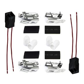 2 Pack ERR117 Range Stove Element Plug Receptacle Block Terminal Block Range for Receptacle Whirlpool Kenmore Electric Stove Range Burner Receptacle Kit 550226, 71930, 74-06-132, 74-06-190, 766339
SAR 72
2 Pack ERR117 Range Stove Element Plug Receptacle Block Terminal Block Range for Receptacle Whirlpool Kenmore Electric Stove Range Burner Receptacle Kit 550226, 71930, 74-06-132, 74-06-190, 766339
SAR 72
 Yitu Fengshun Replace APS7014646 Refrigerator Door Light Switch replacement for Sub Zero
SAR 61
Yitu Fengshun Replace APS7014646 Refrigerator Door Light Switch replacement for Sub Zero
SAR 61
 -39%
Red Beads Long Statement Necklace Multi-Strand Waterfall Chains with Crystal Beads Charms Pendant
SAR 89
-39%
Red Beads Long Statement Necklace Multi-Strand Waterfall Chains with Crystal Beads Charms Pendant
SAR 89
 Coach Elliot Women's Watch | Quartz Movement | Water Resistant | Classic Minimalist Design for Every Occasion (Model 14504245)
SAR 784
Coach Elliot Women's Watch | Quartz Movement | Water Resistant | Classic Minimalist Design for Every Occasion (Model 14504245)
SAR 784


