- التسوق ، اصبح سهلا.
- /
- احصل على التطبيق!
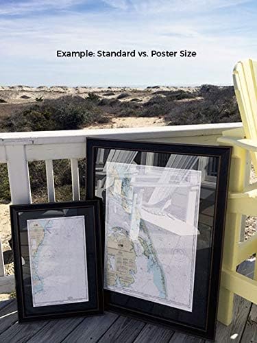
Point Judith Harbor, RI NOAA 13219. This Framed Nautical Map covers the waters and coast line of Point Judith Harbor, Rhode Island. The Framed Nautical Chart is the official NOAA Nautical Chart detailing the waters of the beautiful Point Judith Harbor; including Point Judith Neck, Snug Harbor, Potter Pond, and Point Judith Pond. NOAA Nautical Chart 13219. Standard frame is approx 18" H x 24" W. Poster frame is approx 28" H x 36" W. Solid Hardwood Frame, Glass Front, Black Mat, Paper Duster Backing with Wire Hanging, Handmade in USA
 شامبو وغسول بابو بوتانيكالز للبشرة الحساسة 2 في 1 خالي من العطور - مع زبدة الشيا والآذريون والصبار - تم التحقق من مجموعة العمل البيئي (EWG)، ولم يتم الإساءة إلى الحيوانات لتصنيعها، ونباتي - تم اختباره من قبل أطباء الأطفال - 8 أونصة سائلة. أوقية.
SAR 73
شامبو وغسول بابو بوتانيكالز للبشرة الحساسة 2 في 1 خالي من العطور - مع زبدة الشيا والآذريون والصبار - تم التحقق من مجموعة العمل البيئي (EWG)، ولم يتم الإساءة إلى الحيوانات لتصنيعها، ونباتي - تم اختباره من قبل أطباء الأطفال - 8 أونصة سائلة. أوقية.
SAR 73
 حزام السلم والأداة المساعدة Rock-N-Rescue - معدات مكافحة الحرائق والإنقاذ، قابلة للتعديل
SAR 498
حزام السلم والأداة المساعدة Rock-N-Rescue - معدات مكافحة الحرائق والإنقاذ، قابلة للتعديل
SAR 498
 عيد ميلاد مجيد! المستوى 4 (مكتبة البيانو الأساسية لألفريد)
SAR 45
عيد ميلاد مجيد! المستوى 4 (مكتبة البيانو الأساسية لألفريد)
SAR 45
 -18%
كتاب نشاط كارول عيد الميلاد: القراءة المسبقة (10 مفضلات لعيد الميلاد مع صفحات الأنشطة الموسيقية المقابلة لعازف البيانو المبتدئ)
SAR 41
-18%
كتاب نشاط كارول عيد الميلاد: القراءة المسبقة (10 مفضلات لعيد الميلاد مع صفحات الأنشطة الموسيقية المقابلة لعازف البيانو المبتدئ)
SAR 41