- Shopping, made easy.
- /
- Get the app!
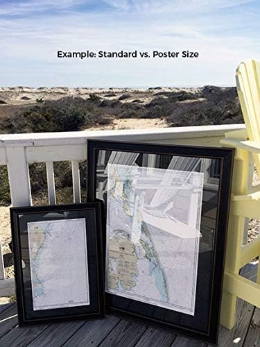
Newburyport Harbor and Plum Island Sound, MA NOAA 13282. This Framed Nautical Map covers the waters of Newburyport Harbor and Plum Island Sound. The Framed Nautical Chart is the official NOAA Nautical Chart detailing the beautiful waters and coastline of Newburyport Harbor and Plum Island Sound; including Ipswich Bay, Bigelow Bight, Merrimack River, Salisbury Beach as well as many other towns and harbors. NOAA Nautical Chart 13282. Standard frame is approx 19" W x 24" H. Poster frame is approx 30" W x 36" H. Solid Hardwood Frame, Glass Front, Black Mat, Paper Duster Backing with Wire Hanging, Handmade in USA.
 Accutime Kids Marvel Avengers Captain America Spiderman Guardians of The Galaxy Analog Quartz Superhero Time Teacher Watch for Boys, Girls, Toddlers with Hour Minute Markers to Learn How to Read Time
SAR 96
Accutime Kids Marvel Avengers Captain America Spiderman Guardians of The Galaxy Analog Quartz Superhero Time Teacher Watch for Boys, Girls, Toddlers with Hour Minute Markers to Learn How to Read Time
SAR 96
 -16%
Howard Leight LL-30 Laser Lite Disposable Foam Corded Earplugs, Polyurethane Foam, One Size, Pink/Yellow (Pack of 100)
SAR 157
-16%
Howard Leight LL-30 Laser Lite Disposable Foam Corded Earplugs, Polyurethane Foam, One Size, Pink/Yellow (Pack of 100)
SAR 157
 Women's Wedding Bridal Mesh Tulle Gloves Long Opera Hallowmas Costume Party Gloves 27" Elbow Length Sheer Gloves
SAR 37
Women's Wedding Bridal Mesh Tulle Gloves Long Opera Hallowmas Costume Party Gloves 27" Elbow Length Sheer Gloves
SAR 37
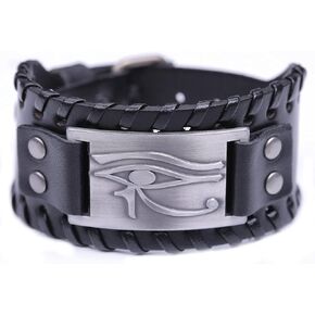 HAQUIL Viking Wiccan Egytian Black Brown Wide Leather Wristband Bracelet Ancient Medieval Jewelry Gift for Men
SAR 47
HAQUIL Viking Wiccan Egytian Black Brown Wide Leather Wristband Bracelet Ancient Medieval Jewelry Gift for Men
SAR 47