- Shopping, made easy.
- /
- Get the app!
Unique, color banded, this political LARGE PRINT map of WYOMING state features geographic details. The map shows all county boundaries, county names with their capitals. Perfect for Schools, Home, Office or Home Schooling.
 -8%
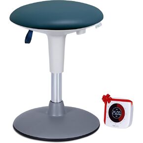
Adjustable Wobble Stool for Kids Ages 7-12 Years; Flexible Seating Stools for Classroom; Ergonomic Wiggle Seat, 360 Degrees Movement; Bonus Rechargeable Visual Timer (Sky Blue)
SAR 579
-8%
Adjustable Wobble Stool for Kids Ages 7-12 Years; Flexible Seating Stools for Classroom; Ergonomic Wiggle Seat, 360 Degrees Movement; Bonus Rechargeable Visual Timer (Sky Blue)
SAR 579
 -16%
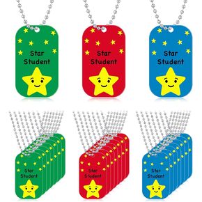
24 Pcs Student Incentives Metal Star Student Dog Tag with Chains Recognition Tag Necklaces Education Awards Prizes Bulk for School Classroom Reward Teacher Supplies
SAR 53
-16%
24 Pcs Student Incentives Metal Star Student Dog Tag with Chains Recognition Tag Necklaces Education Awards Prizes Bulk for School Classroom Reward Teacher Supplies
SAR 53
 -10%
tickit Sensory Mood Light Table | 20 Colors | Rechargeable | Sensory Room Lights | Large Play Table for Toddlers
SAR 1,207
-10%
tickit Sensory Mood Light Table | 20 Colors | Rechargeable | Sensory Room Lights | Large Play Table for Toddlers
SAR 1,207
 -5%
PATIKIL Award Ribbons, 18 Pcs 4th Place Prize Medal Ribbon with Event Card & Rope for Sports Events Competitions Challenges Prize Ornaments, Yellow
SAR 60
-5%
PATIKIL Award Ribbons, 18 Pcs 4th Place Prize Medal Ribbon with Event Card & Rope for Sports Events Competitions Challenges Prize Ornaments, Yellow
SAR 60

