- Shopping, made easy.
- /
- Get the app!

Unique, color banded, this political LARGE PRINT map of Texas state features geographic details. The map shows all county boundaries, county names with their capitals. Inset maps show the Houston, San Antonio, Fort Worth-Dallas area. Selection of cities, roads and major Geographical features. Perfect for Schools, Home, and Office. Size 24"W x 25"H inches or 30"Wx31"H (paper or laminated) - Made/printed in U.S.A. 2025 - Original and authentic cartographic work.
 HISTORIX 2021 North America Map - 18x24 Inch Map of North America Wall Art - Mapa de America - North America Wall Map - Map of North America Poster
SAR 209
HISTORIX 2021 North America Map - 18x24 Inch Map of North America Wall Art - Mapa de America - North America Wall Map - Map of North America Poster
SAR 209
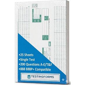 TEST-100E 882 E Compatible Testing Forms (50 Sheet Pack)
SAR 48
TEST-100E 882 E Compatible Testing Forms (50 Sheet Pack)
SAR 48
 200 Christian Question Cards for Inspirational Conversations - Explore Your Faith and Have Fun on Family Game Night, Bible Study or Youth Groups - Perfect Couples Religious Gifts for Women or Men
SAR 157
200 Christian Question Cards for Inspirational Conversations - Explore Your Faith and Have Fun on Family Game Night, Bible Study or Youth Groups - Perfect Couples Religious Gifts for Women or Men
SAR 157
 -35%
Learning Resources View-Thru Geometric Solids - Geometric Shapes, Back to School Supplies Must Haves, Math Teacher Supplies
SAR 68
-35%
Learning Resources View-Thru Geometric Solids - Geometric Shapes, Back to School Supplies Must Haves, Math Teacher Supplies
SAR 68