- Shopping, made easy.
- /
- Get the app!
New Bedford Harbor and Approaches 13232. This Framed Nautical Map covers the waters and coast line of New Bedford Harbor and approaches. The Framed Nautical Chart is the official NOAA Nautical Chart detailing the beautiful waters of New Bedford Harbor; including Acushnet River, New Bedford, Fairhaven, Mattapoisett Harbor, Nasketucket Bay, Buzzards Bay, Apponagansett Bay, West Island, and other towns and harbors..Product Details: NOAA Nautical Chart 13232. Standard Frame is 20 1/4" H. x 24" W. Poster frame is 30 1/2‚ H x 36" W. Solid Hardwood Frame, Glass Front, Black Matte, Paper Duster Backing with Wire Hanging, Handmade in USA
![Certain Women (The Criterion Collection) [Blu-ray] in Saudi Arabia](https://cdn1.tilga.com/md/prod/1/1453/3/38249691.48218.jpg) -30%
Certain Women (The Criterion Collection) [Blu-ray]
SAR 147
-30%
Certain Women (The Criterion Collection) [Blu-ray]
SAR 147
 -79%
Leg Avenue Women's Industrial Fishnet Sleeve Bodystocking
SAR 26
-79%
Leg Avenue Women's Industrial Fishnet Sleeve Bodystocking
SAR 26
 Earblity 2PCS Hypoallergenic 316L Stainless Steel Printed Round,Spider Web,Bamboo Design Ear Weights Hangers For Stretched Ear Lobe Piercing Ear Plugs Gauges Body Jewelry
SAR 115
Earblity 2PCS Hypoallergenic 316L Stainless Steel Printed Round,Spider Web,Bamboo Design Ear Weights Hangers For Stretched Ear Lobe Piercing Ear Plugs Gauges Body Jewelry
SAR 115
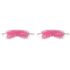 -38%
TheraPearl Eye Mask, Eye-ssential Mask with Flexible Gel Beads for Hot Cold Therapy,
SAR 32
-38%
TheraPearl Eye Mask, Eye-ssential Mask with Flexible Gel Beads for Hot Cold Therapy,
SAR 32


