- Shopping, made easy.
- /
- Get the app!
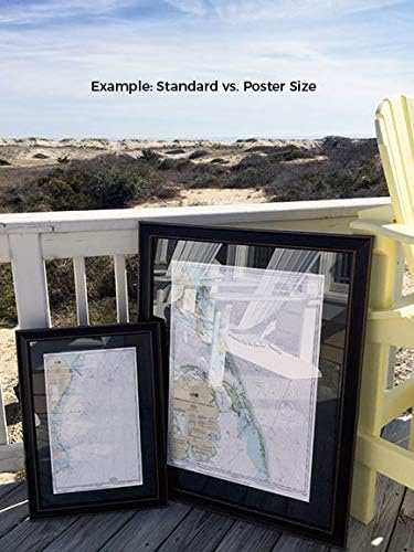
New York Lower Bay (Northern Part) NOAA 12402. This Framed Nautical Map covers the waterways and coast line of the New York Lower Bay (Northern Part). The Framed Nautical Chart is the official NOAA Nautical Chart detailing the beautiful waters of the bay; including Staten Island, Coney Island, Gravesend Bay and Parts of Brooklyn. NOAA Nautical Chart 12402. Standard frame is approx 18" H x 24‚ W. Poster frame is approx 28" H x 36" W. Solid Hardwood Frame, Glass Front, Black Mat, Paper Duster Backing with Wire Hanging, Handmade in USA
 -15%
Thoroughly Modern Dresden: Quick & Easy Construction 13 Lively Quilt Projects for All Skill Levels
SAR 124
-15%
Thoroughly Modern Dresden: Quick & Easy Construction 13 Lively Quilt Projects for All Skill Levels
SAR 124
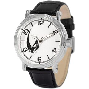 Star Wars The Mandalorian Adult Vintage Analog Quartz Watch
SAR 100
Star Wars The Mandalorian Adult Vintage Analog Quartz Watch
SAR 100
 -42%
A Camping Spree with Mr. Magee: (Read Aloud Books, Series Books for Kids, Books for Early Readers) (Mr. Magee, MCGE)
SAR 58
-42%
A Camping Spree with Mr. Magee: (Read Aloud Books, Series Books for Kids, Books for Early Readers) (Mr. Magee, MCGE)
SAR 58
 Gzrlyf Cheer Coach Notebook Journal only the Strongest Women Become Cheer Coaches Journal Female Cheerleading Coach Gifts (strongest women)
SAR 83
Gzrlyf Cheer Coach Notebook Journal only the Strongest Women Become Cheer Coaches Journal Female Cheerleading Coach Gifts (strongest women)
SAR 83