- Shopping, made easy.
- /
- Get the app!
Martha's Vineyard, MA NOAA 13233. This Framed Nautical Map covers the waters and coast line of Martha's Vineyard, MA. The Framed Nautical Chart is the official NOAA Nautical Chart detailing the beautiful waters surrounding Martha's Vineyard Island; including Nashawena Island, Pasque Island, Naushon Island, Nonameset Island, Buzzards Bay, Vineyard Sound and other towns and harbors. NOAA Nautical Chart 13233. Standard frame is approx 20" H x 24" W. Poster frame is 31" H x 36" W. Solid Hardwood Frame, Glass Front, Black Mat, Paper Duster Backing with Wire Hanging, Handmade in USA
 Reusable Menstrual Pads. 100% Cotton (BrownHaze)
SAR 63
Reusable Menstrual Pads. 100% Cotton (BrownHaze)
SAR 63
 PolyJolly Embroidery Jalabiya Chiffon Abaya Dress for Women Dubai Sadui Muslim Eid Clothes with Headwrap
SAR 344
PolyJolly Embroidery Jalabiya Chiffon Abaya Dress for Women Dubai Sadui Muslim Eid Clothes with Headwrap
SAR 344
 -36%
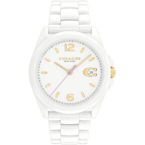
Coach Greyson Women's Watch | Water Resistant | Quartz Movement | Elevating Elegance for Every Occasion(Model 14503926)
SAR 906
-36%
Coach Greyson Women's Watch | Water Resistant | Quartz Movement | Elevating Elegance for Every Occasion(Model 14503926)
SAR 906
 -30%
Coach Swing Zip, Chalk
SAR 1,331
-30%
Coach Swing Zip, Chalk
SAR 1,331


