- Shopping, made easy.
- /
- Get the app!
 -7%
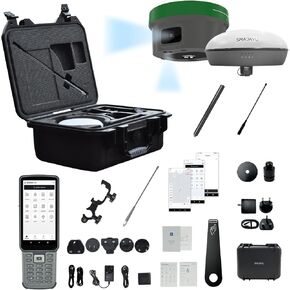
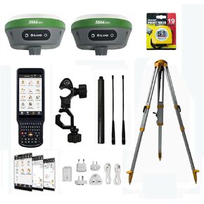
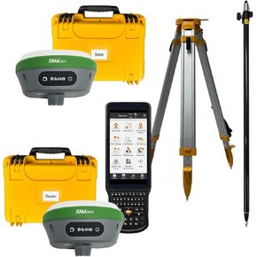
SMA26 RTK Rover with Collector Installed Permanent Surveying Software, RTK Receiver NOAA certificated,Static Survey,RTK Survey by CORS and PPP Survey for Topographic,Land Surveying (Exclude Pole)
SAR 6,956
-7%
SMA26 RTK Rover with Collector Installed Permanent Surveying Software, RTK Receiver NOAA certificated,Static Survey,RTK Survey by CORS and PPP Survey for Topographic,Land Surveying (Exclude Pole)
SAR 6,956
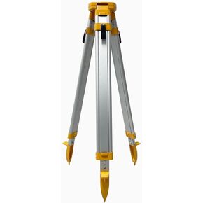 Surveying Tripod Aluminum Survey Tripod Stand Stretchable Tripod
SAR 673
Surveying Tripod Aluminum Survey Tripod Stand Stretchable Tripod
SAR 673
 GPS Poles for Land Surveying Engineering Land Surveying Tool GNSS RTK Pole Double Scale Meters and Feet
SAR 673
GPS Poles for Land Surveying Engineering Land Surveying Tool GNSS RTK Pole Double Scale Meters and Feet
SAR 673
 -9%
SMA20RTK PPK PPP IMU NOAA certificated GNSS Land Surveying Equipment Rover Base Collector with Software, 25km Distance 3±cm Accuracy by PPK, (Exclude Tripod&Pole)
SAR 10,416
-9%
SMA20RTK PPK PPP IMU NOAA certificated GNSS Land Surveying Equipment Rover Base Collector with Software, 25km Distance 3±cm Accuracy by PPK, (Exclude Tripod&Pole)
SAR 10,416
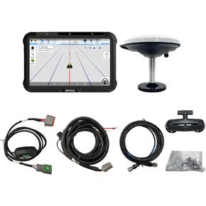
 SMA10 Tractor GPS Guidance System for Agriculture, Precision Farming Navigation System with PPP and SBAS, 10cm Accuracy by PPP, High Accuracy Anti-Interference GNSS Antenna
SAR 6,165
SMA10 Tractor GPS Guidance System for Agriculture, Precision Farming Navigation System with PPP and SBAS, 10cm Accuracy by PPP, High Accuracy Anti-Interference GNSS Antenna
SAR 6,165
 -27%
SMA26 GNSS IMU RTK GPS Surveying Equipment Rover Base Handheld Collector and Survey Software, NOAA certificated, 1408 Channels, 1cm Accuracy(Exclude Tripod&Pole)
SAR 8,819
-27%
SMA26 GNSS IMU RTK GPS Surveying Equipment Rover Base Handheld Collector and Survey Software, NOAA certificated, 1408 Channels, 1cm Accuracy(Exclude Tripod&Pole)
SAR 8,819
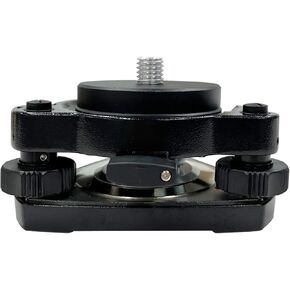 Tribrach with Optical Plummet & Fixed Adapter, Diameter 60mm, 5/8InX11 Mount Rotate Screw for Surveying Equipment RTK Base Station GPS GNSS Easy Install Easy to Use, Black
SAR 511
Tribrach with Optical Plummet & Fixed Adapter, Diameter 60mm, 5/8InX11 Mount Rotate Screw for Surveying Equipment RTK Base Station GPS GNSS Easy Install Easy to Use, Black
SAR 511
 -3%
JY305 Tractor Auto Steer System 2.5cm Accuracy with RTK Base and PPP Mode 10cm+ Accuracy, Planting,Spraying,harvesting Alone AB line in Straight/Curve or A+ line, Pivot,U-Turn..
SAR 13,835
-3%
JY305 Tractor Auto Steer System 2.5cm Accuracy with RTK Base and PPP Mode 10cm+ Accuracy, Planting,Spraying,harvesting Alone AB line in Straight/Curve or A+ line, Pivot,U-Turn..
SAR 13,835
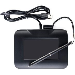 Electronic Signature Pad USB Signature Capture Pads for Computer Laptop with Windows 7,8,10,11,Signature Tool Included,4.3inch LCD Color Display with LCD Backlits
SAR 720
Electronic Signature Pad USB Signature Capture Pads for Computer Laptop with Windows 7,8,10,11,Signature Tool Included,4.3inch LCD Color Display with LCD Backlits
SAR 720
 R26 V1 Rover GNSS Surveying Rover with LP80 collector R26 RTK Receiver NOAA certificated,Static survey,RTK survey for topographic survey,land survey, correction by CORS,Mobile base,TCPIP..
SAR 6,169
R26 V1 Rover GNSS Surveying Rover with LP80 collector R26 RTK Receiver NOAA certificated,Static survey,RTK survey for topographic survey,land survey, correction by CORS,Mobile base,TCPIP..
SAR 6,169
 JY100 V1 Tractor GPS Guidance System 30cm Accuracy High Precision Farming GPS Strong Anti-Interference GNSS Antenna,Works Without Internet Suitable for Various Tractors
SAR 3,680
JY100 V1 Tractor GPS Guidance System 30cm Accuracy High Precision Farming GPS Strong Anti-Interference GNSS Antenna,Works Without Internet Suitable for Various Tractors
SAR 3,680
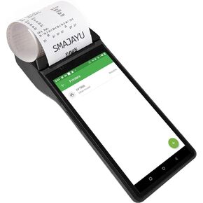 Pos Terminal Receipt Printer Android 10 Handheld Mobile POS with 4G,WiFi,Bluetooth, 58mm Thermal Receipt Printing for Small Business Retail,Built-in Google Play Support Android Software
SAR 910
Pos Terminal Receipt Printer Android 10 Handheld Mobile POS with 4G,WiFi,Bluetooth, 58mm Thermal Receipt Printing for Small Business Retail,Built-in Google Play Support Android Software
SAR 910
 -11%
JY100 V2 GNSS Guidance System for Tractor 30cm High Accuracy GNSS Antenna Strong Anti-Interference Support A-B line Navigation Farm Management,Imperial Measurement
SAR 3,932
-11%
JY100 V2 GNSS Guidance System for Tractor 30cm High Accuracy GNSS Antenna Strong Anti-Interference Support A-B line Navigation Farm Management,Imperial Measurement
SAR 3,932
 SMAJAYU R26 GNSS GPS RTK Base Station GNSS Receiver High Accuracy Static Surveying; Coodinates Collection; Point Surveying
SAR 4,606
SMAJAYU R26 GNSS GPS RTK Base Station GNSS Receiver High Accuracy Static Surveying; Coodinates Collection; Point Surveying
SAR 4,606
 SMAJAYU R26 V2 GNSS IMU RTK GPS Surveying Equipment Rover Base Handheld,IMU Built-in, 1408 Channels, 1cm Accuracy, 5km Distance
SAR 11,431
SMAJAYU R26 V2 GNSS IMU RTK GPS Surveying Equipment Rover Base Handheld,IMU Built-in, 1408 Channels, 1cm Accuracy, 5km Distance
SAR 11,431
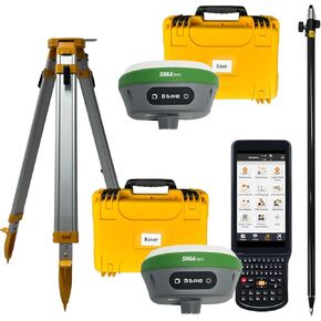
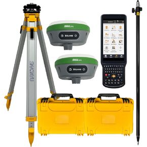 RTK GPS with Tripod, Pole and Tribrach with Optical Plummet & Fixed Adapter Survey Equipment GPS Receiver with IMU Rover & Base Handheld Collector Survey Software SMA26
SAR 10,765
RTK GPS with Tripod, Pole and Tribrach with Optical Plummet & Fixed Adapter Survey Equipment GPS Receiver with IMU Rover & Base Handheld Collector Survey Software SMA26
SAR 10,765
 -0%
SMA26 RTK Surveying Equipment Rover Base Collector Surveying Software IMU RTK Surveying Static Surveying coodinates Collection(Include Surveying Tripod)
SAR 8,952
-0%
SMA26 RTK Surveying Equipment Rover Base Collector Surveying Software IMU RTK Surveying Static Surveying coodinates Collection(Include Surveying Tripod)
SAR 8,952
 SMA20 RTK Rover, PPK PPP IMU NOAA certificated GNSS Land Surveying Rover,Software,1408channes, Connect CORS for Correction,1 inch Accuracy PPK Calculation 900MHz Radio Whip Antenna (Exclude Pole)
SAR 6,444
SMA20 RTK Rover, PPK PPP IMU NOAA certificated GNSS Land Surveying Rover,Software,1408channes, Connect CORS for Correction,1 inch Accuracy PPK Calculation 900MHz Radio Whip Antenna (Exclude Pole)
SAR 6,444
 SMA20 Pro RTK PPK PPP IMU NOAA certificated GNSS RTK Rover Base Collector, Survey Software, PPK Calculation, Up to 25km by PPK, 1cm RTK Accuracy, 400MHz, Ideal UHF 18km(Exclude Tripod&Pole)
SAR 11,118
SMA20 Pro RTK PPK PPP IMU NOAA certificated GNSS RTK Rover Base Collector, Survey Software, PPK Calculation, Up to 25km by PPK, 1cm RTK Accuracy, 400MHz, Ideal UHF 18km(Exclude Tripod&Pole)
SAR 11,118
 -8%
SMA26 RTK GPS Rover RTK Base Station Collector with Permanent Software for Rover, IMU RTK Tilt Surveying, 30-60 Degree, 0.5-2.5cm Accuracy, 5-8km Range(Include Tripod and Pole)
SAR 11,819
-8%
SMA26 RTK GPS Rover RTK Base Station Collector with Permanent Software for Rover, IMU RTK Tilt Surveying, 30-60 Degree, 0.5-2.5cm Accuracy, 5-8km Range(Include Tripod and Pole)
SAR 11,819
 FP430S Electronic Signature Pad USB Signature Capture Pads for Computer Laptop with Windows 7,8,10,11,Signature Stylus Included,4.3inch LCD Color Display with LCD Backlits
SAR 720
FP430S Electronic Signature Pad USB Signature Capture Pads for Computer Laptop with Windows 7,8,10,11,Signature Stylus Included,4.3inch LCD Color Display with LCD Backlits
SAR 720
 601A GNSS Antenna NOAA certificated for JY100 Tractor GPS Guidance System Strong Anti-Interference GNSS GPS GLONASS Galileo Multiple Bands High Precision
SAR 793
601A GNSS Antenna NOAA certificated for JY100 Tractor GPS Guidance System Strong Anti-Interference GNSS GPS GLONASS Galileo Multiple Bands High Precision
SAR 793
 -0%
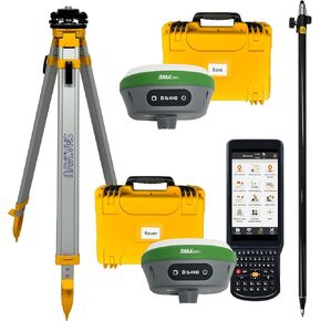
RTK GNSS Survey Equipment GPS Receiver IMU Rover & Base Handheld Collector Survey Software SMA26 Static Survey (Include Pole, Tribrach, Tripod)
SAR 10,368
-0%
RTK GNSS Survey Equipment GPS Receiver IMU Rover & Base Handheld Collector Survey Software SMA26 Static Survey (Include Pole, Tribrach, Tripod)
SAR 10,368
 SMA25R Net GNSS RTK Survey Equipment, Android Handheld GPS Positioning Rover Receiver with Software, CORS Connection, 10cm Accuracy by PPP, 0-60° Tilt Compensation, for Land Surveying, Construction
SAR 3,211
SMA25R Net GNSS RTK Survey Equipment, Android Handheld GPS Positioning Rover Receiver with Software, CORS Connection, 10cm Accuracy by PPP, 0-60° Tilt Compensation, for Land Surveying, Construction
SAR 3,211
 -9%
SMA26 Surveying Equipment Rover Base Collector Surveying Software Permanently Valid (Including Tripod and Pole)
SAR 11,824
-9%
SMA26 Surveying Equipment Rover Base Collector Surveying Software Permanently Valid (Including Tripod and Pole)
SAR 11,824
 SMA28H Laser RTK GNSS Survey System | 2cm Accuracy | Dual Cameras Non-Contact Laser Range (30m Max), AR Real Scene Stakeout, 120° IMU, 15km UHF, 4G/WiFi, PPP/PPK/RTK/CORS Compatible (Receiver Only)
SAR 10,628
SMA28H Laser RTK GNSS Survey System | 2cm Accuracy | Dual Cameras Non-Contact Laser Range (30m Max), AR Real Scene Stakeout, 120° IMU, 15km UHF, 4G/WiFi, PPP/PPK/RTK/CORS Compatible (Receiver Only)
SAR 10,628
 Tractor GPS Guidance System 10inch Precision Ag Software Activated,2.5cm Accuracy by CORS Compatible for John Deere Various Tractors 30cm Accuracy no Need Subscription JY100
SAR 3,680
Tractor GPS Guidance System 10inch Precision Ag Software Activated,2.5cm Accuracy by CORS Compatible for John Deere Various Tractors 30cm Accuracy no Need Subscription JY100
SAR 3,680
 SMA26 RTK Base Station High-Precision GNSS Receiver NOAA certificated (Included Surveying Tripod)
SAR 5,704
SMA26 RTK Base Station High-Precision GNSS Receiver NOAA certificated (Included Surveying Tripod)
SAR 5,704